Roads and Highways
Save time, enhance efficiency, and ensure safety with our drone-powered solutions.
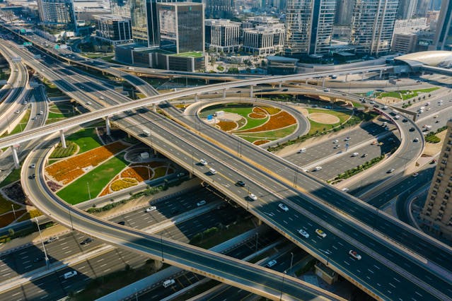
Roadways
Drone survey, inspection and monitoring for the Transport industry
Ninetrontech’s cutting-edge drone solutions revolutionize the railway and roadway industries by streamlining project planning, construction monitoring, and infrastructure inspections. We assist various railway and roadway agencies with aerial surveys, inspections, and monitoring using high-end drones equipped with high-resolution sensors. These deliver superior data accuracy up to centimeter-level precision ensuring efficient project execution while maintaining safety and compliance.
Our drone-based aerial surveys provide critical data, including:
✅ Orthophotos
✅ Elevation Models
✅ Terrain Models
✅ 3D Models
✅ Thermographic Data
With faster turnaround times, our dedicated drone pilots and GIS experts deliver high-accuracy results, often ahead of schedule.
Planning
Pre Construction Survey
The pre-construction survey is an essential step in planning and land assessment before any project begins. Our high-resolution drones capture detailed data on existing terrain, structures, utility lines, drainage slopes, land gradients, and soil conditions. This comprehensive aerial analysis helps project managers make data-driven decisions faster and ensures precise planning with 2D maps, 3D models, and topographical data.
Construction
Project Progress Monitoring
Monitoring project progress is crucial for budget control and timeline efficiency. Our Aerial Construction Monitoring Solution enables project managers to reduce overall construction time, identify delays, and detect unfinished structures such as overpass pillars and road embankments. By continuously tracking progress and ensuring compliance with blueprints and safety standards, drone-based monitoring significantly improves efficiency.
Assets Management
Volume Estimation
For volume estimation and asset management, we utilize AI-powered drone surveys that achieve up to 99% accuracy in stockpile volume estimation. This enables better resource tracking, cost-efficient budgeting by reducing material waste, and faster, more precise supply chain planning. Our technology helps project managers maintain full visibility over construction materials, improving operational efficiency.
Inspection
Roads & Highways
Road and highway inspections are made safer and more efficient with our drones, which are equipped with advanced RGB and thermal sensors. They provide high-resolution aerial data for identifying potholes, cracks, crash barrier misalignments, divider placements, and soil embankment conditions. By creating detailed topographic maps, we help authorities detect risks early, allowing them to take preventive measures and ensure better road maintenance.
Inspection
Bridge
Bridge inspections, traditionally requiring scaffolding and manual labor, often pose high risks and long downtimes. Our drone-based bridge inspection solutions provide a safer and more efficient alternative by allowing access to hard-to-reach areas without endangering personnel. With high-resolution GIS maps and 3D models, we can analyze structural integrity, detect concrete delamination, and assess riverbank erosion upstream and downstream of bridge foundations. This data enables authorities to strengthen and maintain bridges with minimal disruption.
Our Features
1000+ km Highway
Already covered 1000+ km of highway and helped project managers and authorities to ensure accountability & increase efficiency.
50 km Highway Per Day
With experienced pilots & high-end survey drones we can easily scale up to cover 50 km of highways & roads in a day.
Faster Data Delivery
We have a team of GIS experts working around the clock to process and analyze the drone data to deliver the reports on time.
Benefits of our Drone Powered solution for Roadways
Drones offer superior resolution for inspections than ground-based methods.
- Increase efficiency with high-resolution data in a very timely manner with 4k capabilities.
- Safely monitor and inspect the condition of Highways without endangering any personnel.
- Save cost, time and resources with Drone Survey & Inspection compared to ground-based approach.
- Keep track of all the construction materials with AI and Drones.